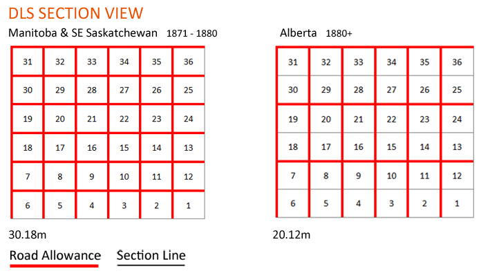
 Road Allowances
The following guide is used to aid in understanding road allowances within the Dominion Land Survey system.
Road Allowance Width:
Alberta/Saskatchewan |
20.12m |
Manitoba |
30.18m |
General Principles

Road allowances are designated fixed width areas that run inbetween certain sections of a township. Although many road allowances contain physical roads, not all road allowances have an actual road built on them. Road allowances are one of the differences between the Canadian DLS and the American Public Land Survey System, which leaves no extra space for roads.
The road allowances add to the size of the township (they do not cut down the size of the sections): This is the reason the baselines are not exactly 39km apart.
Differences between Road Allowances

Many different surveys took place in the late 1800's, with two being prominently used today. Surveys that took place between 1871 to 1880 encompass most of southern Manitoba, parts of south eastern Saskatchewan and around the Prince Albert area. The important difference between the two survey methods are the width of the road allowances, and the frequency of road allowances in between each township.
Sections surveyed from 1871-1880 (Manitoba & SE Saskatchewan) contain road allowances that are 30.18m wide (1.5 chains), run north-south and east-west between all townships.
Sections surveyed from 1880 onward contain road allowances that are 20.12m wide (1 chain), but running east-west only fall on the north side of townships 7 to 12, 19 to 24, and 31 to 36. This results in a road allowance every mile progressing east-west and every two miles progressing north-south.
Hard Boundaries

Measured from the edge of the section in Alberta/Saskatchewan.
Measured from the middle of the road allowance in Manitoba.
*The above information should be used as guidelines only, and is based on past field experience. Clear Directional has made every effort to ensure the accuracy of the information contained within, and does not warrant nor guarantee the content.